
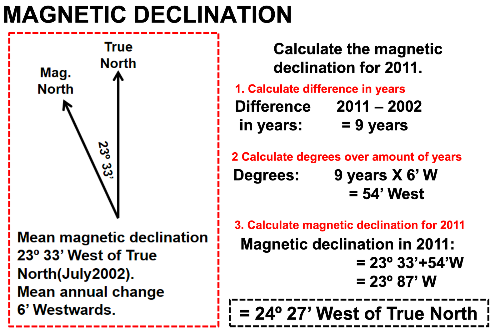
How to Calculate Magnetic Declination in Geography (magnetic declination formula calculations) : First of all, let’s understand what Magnetic Declination is. The angle between magnetic north and true north is what called magnetic declination. Magnetic declination is also referred to as magnetic variation.
Magnetic declination can also be understood as the difference in degrees between True North and MAGNETIC North.
Steps on How to Calculate Magnetic Declination in Geography
Magnetic declination is the angle between true north and magnetic north, and it varies depending on the location on the Earth’s surface. Here’s how to calculate magnetic declination in Geography:
- Determine your location: Find the location of the place where you want to calculate the magnetic declination. You can use a map, GPS or online resources to determine the coordinates of your location.
- Look up the declination: You can use various online resources to find the magnetic declination for your location. The National Oceanic and Atmospheric Administration (NOAA) provides an online calculator that allows you to look up the magnetic declination for any location in the world.
- Calculate the magnetic declination: Once you have obtained the magnetic declination for your location, you can calculate it using a compass. Hold the compass level and parallel to the ground, and align the compass needle with magnetic north. Then, rotate the compass housing until the orienting arrow points to true north. The angle between the orienting arrow and the compass needle is the magnetic declination.
It’s important to note that magnetic declination changes over time and varies depending on your location, so it’s important to use up-to-date information and check the accuracy of your compass regularly.
Did you know? By convention, declination is positive when magnetic north is east of true north, and negative when it is to the west. Isogonic lines are lines on the Earth’s surface along which the declination has the same constant value, and lines along which the declination is zero are called agonic lines. The lowercase Greek letter δ (delta) is frequently used as the symbol for magnetic declination.
Video Guide on how to Calculate Magnetic Declination in Geography
How to calculate magnetic bearing
In order to calculate magnetic bearing, you follow the steps below:
- Step 1: Determine the true bearing E.g 75°
- Step 2: Determine the difference in years between the current year & the year
the Magnetic declination was measured (on topographic map). E.g. 2015 – 2005 = 10 years - Step 2: Calculate the total magnetic change
E.g 10 years x 2’ West = 20’ West (On the topographic map the change is 2’ West every year) - Step 3: Calculate the current magnetic declination
E.g 16°3’ West + 0°20’ West, When the mean annual change is west you add, & if the change is East, you subtract. = 16°23’ West Therefore, the magnetic declination for 2015 is 16°23’ west from True North. - Step 4: Calculate the magnetic bearing
E.g True Bearing + Current Magnetic Declination
= 75° + 16°23’
= 91°21’ west.
Get Free Help for Your Assignment Today
Click the Button Below: