
On this page, we have gathered Mid-latitude Cyclone Grade 12 Questions and Answers from past question papers. It will make it easy for Grade 12 Geography students to revise the Mid Latitude Cyclone section for their exams and tests.
This also helps to see how the Grade 12 Mid-latitude Cyclone questions are structured, which will give you an idea on what to expect during the final examination.
List of Mid-latitude Cyclone Grade 12 Questions and Answers
Below you will find the mid-latitude cyclone questions and answers based on the 2023 Grade 12 Geography paper 1 question paper:

1.3.1 The mid-latitude cyclone mentioned in the extract is in the (initial/mature) stage.
Answer: Mature (1)
1.3.2 Give a reason for your answer to QUESTION 1.3.1.
Answer:
- A well-developed cold front (2)
- Widespread rainfall to the Western Cape / Affects the Southwestern Cape / Made landfall (2)
- Well-developed cold sector and warm sector (2)
- Presence of cumulonimbus clouds ahead of the cold front (2)
- Steep gradient (2)
(Any one of the above) (1 x 2) (2)
1.3.3 Why did the rainfall mentioned in the extract spread from Cape Town to Mossel Bay and Knysna?
Answer:
- Driven/steered by Westerly winds (2)
- Mid-latitude cyclones move from west to east (2)
(Any one of the above) (1 x 2) (2)
1.3.4 Refer to the graph and determine the lowest and highest rainfall, in millimetres, recorded in the Western Cape over 36 hours.
Answer:
- Lowest: 15 mm (1)
- Highest: 40 mm (1)
(2 x 1) (2)
1.3.5 With reference to the cross-section, explain how a well-developed cold front results in heavy rainfall over the Western Cape.
Answer:
- Cold front (cold air) undercuts warm moist air (2)
- Rapid uplift of warm moist air occurs (2)
- Rising air cools and condenses (2)
- Cumulonimbus clouds develop (great vertical extent) (2)
(Any two processes) (2 x 2) (4)
1.3.6 How will the heavy rainfall negatively affect the physical (natural) environment in and around the Western Cape?
Answer:
- Soil erosion (accept examples) (2)
- Biodiversity will be destroyed (2)
- Destruction of natural habitat (accept examples) (2)
- Destruction of natural vegetation (2)
- Loss of wildlife (2)
- Disruption of food chains/ecosystems (2)
- Mass movements (e.g. landslides, mudslides) (2)
- Fertilisers washed into rivers (causing eutrophication) (2)
- Water pollution (accept examples) (2)
- Leaching of soil nutrients (2)
- Flooding in low-lying areas (2)
- Waterlogged conditions (2)
(Any relevant points) (2 x 2) (4)
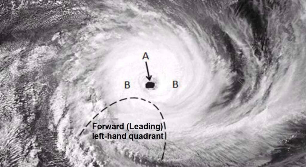
Refer to the satellite image of a tropical cyclone in the mature stage below
Tropical Cyclone – Questions & Answers
1.4.1 State ONE condition required for the development of a tropical cyclone.
Answer:
- Presence of Coriolis force (1)
- Ocean surface temperature of at least 26.5°C (1)
- Calm surface conditions for several days / less friction (1)
- Presence of low air pressure (1)
- Unstable atmospheric conditions (1)
- Evaporation from the sea surface / Rising of warm moist air (1)
- Upper air divergence (1)
- Latent heat (1)
(Any one of the above) (1 x 1) (1)
1.4.2 In which hemisphere did this cyclone develop?
Answer: Southern Hemisphere (1 x 1) (1)
1.4.3 Give a reason for your answer to QUESTION 1.4.2.
Answer:
- Air circulation around the low-pressure cell is clockwise (2)
- The forward (leading) left-hand quadrant/dangerous semi-circle is located on the south-west of the tropical cyclone (2)
(Any one of the above) (1 x 2) (2)
1.4.4 Differentiate between the cloud cover at A and B.
Answer:
- A: Has clear skies (1)
- B: Dense (cumulonimbus) cloud cover (1)
(2 x 1) (2)
1.4.5 Explain why there is a difference in cloud cover at A and B.
Answer:
- At A (eye): Air is descending (heating), resulting in no condensation and no cloud formation (2)
- At B (eye wall): Air is rising (cooling), leading to condensation and cloud formation (2)
(2 x 2) (4)
1.4.6 Why are the strongest winds found in the forward (leading) left-hand quadrant?
Answer:
- Combination of the forward movement and rotation of the system (2)
- It has a steep pressure gradient (2)
(Any one of the above) (1 x 2) (2)
1.4.7 Draw a sketch of a tropical cyclone in its mature stage as represented on a synoptic weather map. Indicate the following on the sketch:
(i) Air pressure reading at the centre of the tropical cyclone
(ii) At least four isobars indicating the correct spacing
(iii) Symbol to represent the tropical cyclone
(3 x 1) (3)

Get Free Help for Your Assignment Today
Click the Button Below: