The Path of the Tropical Cyclone Freddy: An Unprecedented Journey Across the South Indian Ocean:
The World Meteorological Organization (WMO) is convening an expert committee to assess if Tropical Cyclone Freddy has shattered the record as the longest-lasting cyclone ever recorded. Freddy, named a tropical cyclone for an impressive 34 days, traveled over 8,000 kilometers across the entire South Indian Ocean. The accumulated cyclone energy, an index measuring the energy released by a tropical cyclone, is on par with an average full North Atlantic hurricane season.
While the storm has had major socio-economic and humanitarian impacts, the death toll has been mitigated by accurate early warnings from National Meteorological and Hydrological Services. Their coordinated efforts on the ground with disaster management teams have been instrumental in preventing a greater loss of life, highlighting the critical role of Early Warnings for All. Initial unconfirmed reports suggest a death toll of 190.
Tropical Cyclone Freddy Satellite Image Map
The Path of the Tropical Cyclone Freddy: Satellite Image Map
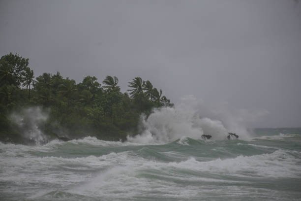
Freddy’s Path of Destruction
Making landfall in northern Mozambique, in the province of Zambezia, on 11 March, this marked Freddy’s second landfall in the country, according to the National Meteorological Hydrological Service (INAM). The storm has brought destructive winds, storm surge, and extreme rainfall to large areas including Northeast Zimbabwe, Southeast Zambia, Malawi, and Mozambique.
Expected total rainfall amounts are between 200 to 300 mm, and as much as 400-500 mm over the landing area of Mozambique and in the mountainous regions. This is more than twice the usual monthly rainfall in just a few days, likely leading to severe floods.
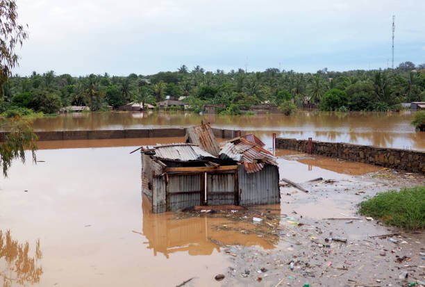
Malawi is bracing for cumulative rainfall of more than 300 to 400 mm in 48 hours, leading to widespread flooding and flash floods. Malawi’s Department of Climate Change and Meteorological Services has urged people to relocate to higher ground, heed evacuation orders, and avoid rivers. They warn of the potential collapse of houses and pit latrines, and damaged power lines.
The ongoing rainfall exacerbates the flooding caused by Freddy’s first passage and heavy seasonal rains, which have already saturated the ground and filled rivers. Southern Mozambique has received over a year’s worth of rainfall in the past month, and Madagascar experienced three times the monthly average in just a week.
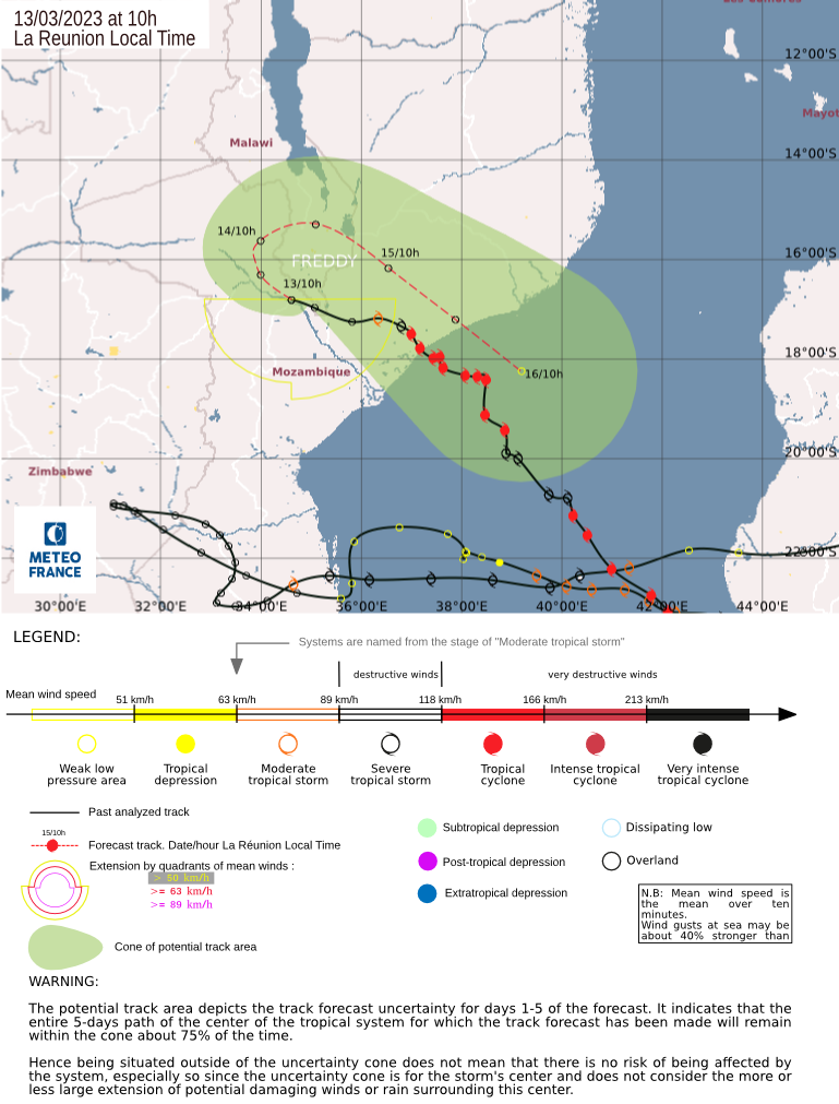
Freddy first made landfall in Madagascar on 21 February, and then in Southern Mozambique on 24 February. It spent several days tracking over Mozambique and Zimbabwe, causing heavy rains and flooding. It then looped back towards the Mozambique Channel, gaining energy from the warm waters and heading towards the south-western coast of Madagascar, before returning to Mozambique.
Early Warnings for All
“Freddy is having a major socio-economic and humanitarian impact on affected communities. The death toll has been limited by accurate forecasts and early warnings, and coordinated disaster risk reduction action on the ground – although even one casualty is one too many,” said Dr. Johan Stander, WMO Services Director.
“This once again underlines the importance of the UN Early Warnings for All initiative to ensure that everyone is protected in the next five years. WMO is committed to working with our partners to achieve this and tackle extreme weather and climate change-related risks – one of the biggest challenges of our times,” he added.
Advanced warnings by WMO’s Regional Specialized Meteorological Centre La Réunion (Meteo-France) and the national meteorological and hydrological services of Madagascar, Mozambique, and Malawi allowed for timely mobilization of disaster management and humanitarian communities. This preparedness enabled evacuations and pre-positioning of food supplies.
A Record-Breaking Storm?
From a meteorological perspective, Freddy is a truly remarkable storm. The Australian Bureau of Meteorology, a WMO regional centre, named Freddy on 6 February while it was still a few hundred kilometers off the northwest coast of Australia. From there, Freddy charted a course across the entire Indian Ocean from east to west, affecting Mauritius and La Réunion on its epic journey to Madagascar. Such an extended zonal track is exceptionally rare, with the most recent recorded cases being Tropical Cyclones Leon-Eline and Hudah, both in 2000, another la Niña year like 2023.
The WMO is closely monitoring Freddy’s progress to determine if it will establish a new record as the longest-lasting tropical cyclone. An investigation by the WMO Weather and Climate Extremes evaluation committee is expected to commence after the cyclone has dissipated.
“The WMO Weather and Climate Extremes Archive are currently assembling a blue-ribbon international committee of scientists. Once the tropical cyclone has dissipated, these experts will begin a detailed examination of the raw data to determine if Freddy has indeed established a record as the longest-duration tropical cyclone on record. One question that we will be addressing is the fact that throughout its long lifetime, the storm has periodically weakened below tropical storm status. We will obviously need to address if that is a concern in our evaluation,” said Prof. Randall Cerveny, WMO Weather and Climate Extremes rapporteur.
“Our evaluations are detailed scientific inquiries so they do take time,” he added.
The current record is held by Hurricane/Typhoon John, which lasted 31 days in 1994. According to NASA, Freddy has set the record for the highest accumulated cyclone energy (ACE) of any southern hemisphere storm in history.
“World record or not, Freddy will remain an exceptional phenomenon for the history of the South-West Indian Ocean on many aspects: longevity, distance covered, remarkable maximum intensity, accumulated cyclone energy (ACE) amount, impact on inhabited lands … but it will be necessary to wait until the system ends its life cycle to make an exhaustive assessment,” said Sebastien Langlade, Head of Operations at RSMC La Réunion.
The Role of Climate Change
The Intergovernmental Panel on Climate Change (IPCC) has reported observed and projected increases in heavy precipitation and pluvial flooding for East Southern Africa and Madagascar. They predict an increase in average tropical cyclone wind speeds, along with associated heavy precipitation and a rise in the proportion of category 4-5 tropical cyclones.
Rising mean sea levels globally will contribute to higher extreme sea levels associated with tropical cyclones. Coastal hazards will be exacerbated by an increase in the average intensity, magnitude of storm surge, and precipitation rates of tropical cyclones. While there is low confidence in changes in the future frequency of tropical cyclones at the global scale, the journey of Tropical Cyclone Freddy and its potential record-breaking duration serve as stark reminders of the changing face of our planet’s weather systems.
Get Free Help for Your Assignment Today
Click the Button Below: